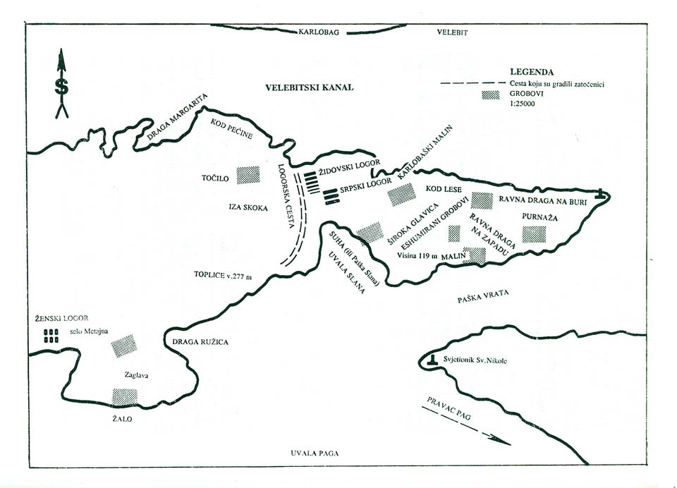
In the middle of the island of Pag there is a long bay which is entered from northeast, from the Mountain Channel, through the “Pag Door” that opens between two capes, St. Nicholas and St. Kristopher (both saints according to Christian beliefs watch over travellers, especially sailors and help them if asked). Slana is located on the part of the hill where St. Kristopher ends, or to put it in better words, the part of the hill where the crime happened starts with the Slana bay and leads towards the lighthouse at end of the cape with the church of St. Kristopher. This hilly crest plunged into the sea of the Mountain Channel is around three kilometres long. It is a mass grave site, only partially explored, destroyed over time, with less and less possibility to preserve the evidence of the crime and make them palpable.
During summer this part of the island looks attractive with its seemingly innocent solitude, primeval peace and distance from the noise, pollution, full of small beaches interrupted with boulders and caves. During gales it becomes a terrible battleground with salty blasts of wind that come crushing from Velebit and brake over this barren rocky crest. With these blasts the rocky limestone sharpens so much that every rock and every piece on that rock has a sharp point that comes out of another and all of them comb the very gale that created them. There are few sinkholes only few meters wide which collect some earth or have hard loam around it, and their underground layers become hidden reservoirs of fresh drinking water. It sometimes comes in drops, reaches the surface, and in one spot it even creates a somewhat abundant spring. The name Malin which this spring has maybe tells us that there was more water here and that someone long ago tried to build a mill (mlin).
The location of Malin is a half way from Slana to the lighthouse on Cape Kristopher. A crest of the hill overlooks it and continues with an uneven plateau of small rocks and scorched earth. This area is called Furnaza (or Fornaza), and the part in the northeast, closer to the Mountain Channel where you can see Karlobag, is called Karlobaška Furnaza. The names are given by the local inhabitants, and since hardly anyone walks around there – because there’s no reason for it , unless someone looses a sheep or a fisherman is forced to land there – most of inhabitants, even rare visitors, do not have fixed names, so they confuse or switch them.
In this discussion we are especially interested in location of “Jewish” and “Serbian” concentration camp, the location of pits, i.e. where killings took place, density of graves and pyres where the exhumed victims were burned. According to all documents (and according to my own investigation from the first day the camp was established, closed and according to later research) whole of this area is a scene of the crime which can be proved with a little effort, and all thing now hidden will be revealed in time in some way. There are reasons for such hope. Even with those undiscovered matters, and which can be sensed through investigation, i.e. the area of graves farther from the recorded pits, all over sandy areas in the part of Furnaza that reaches almost to the lighthouse, and also on crests behind Široka Draga (Baška Slana), in the triangle behind Skok, Pećine and Točilo, The thing that can be reasonably deducted, through documents and examination of the location, is that this rocky camp compound named Slana holds terrifying information on this segment of history, where one of it most horrific pages were written.